Weather forecast algorithm helps spot dangerous cloud formations
The computer model, say the researchers, could help meteorologists make quicker and more accurate predictions in their forecasts. The framework, which ran on the Bridges supercomputer at the Pittsburgh Supercomputing Center, is based on machine learning linear classifiers and detects rotational movements in clouds from satellite images that might have otherwise gone unnoticed.
“The very best forecasting incorporates as much data as possible,” says Steve Wistar, senior forensic meteorologist at AccuWeather. “There’s so much to take in, as the atmosphere is infinitely complex. By using the models and the data we have [in front of us], we’re taking a snapshot of the most complete look of the atmosphere.”
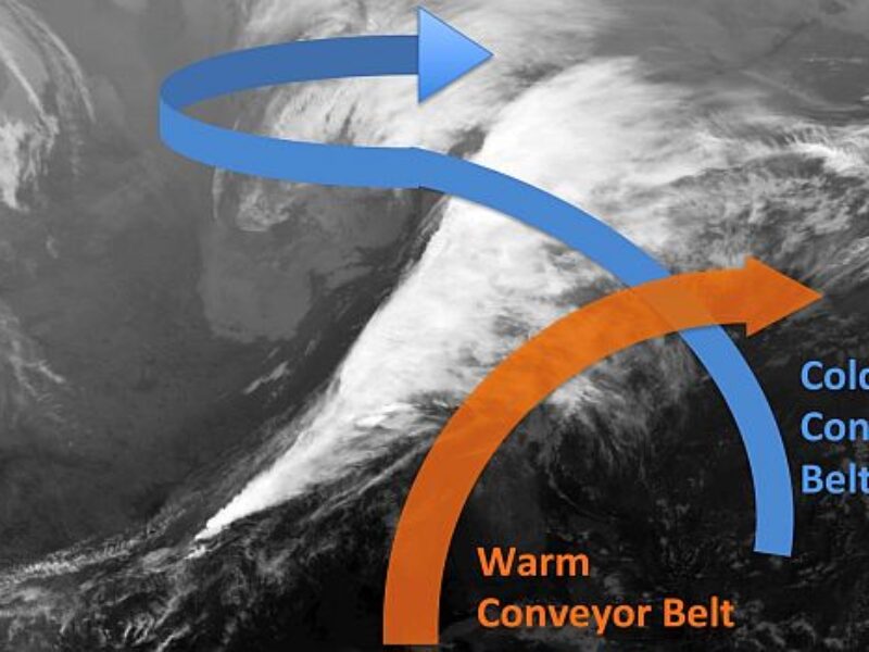
In their work, the researchers worked with Wistar and other AccuWeather meteorologists to analyze more than 50,000 historical U.S. weather satellite images. In them, experts identified and labeled the shape and motion of “comma-shaped” clouds (see image) – cloud patterns that are strongly associated with cyclone formations, which can lead to severe weather events including hail, thunderstorms, high winds, and blizzards.
The researchers then used computer vision and machine learning techniques to teach algorithms to automatically recognize and detect comma-shaped clouds in satellite images. The system can then assist experts by pointing out in real time where, in an ocean of data, could they focus their attention in order to detect the onset of severe weather.
“Because the comma-shaped cloud is a visual indicator of severe weather events,” says Rachel Zheng, a doctoral student in the College of Information Sciences and Technology (IST) at Penn State and the main researcher on the project, “our scheme can help meteorologists forecast such events.”
The researchers found that their method can effectively detect comma-shaped clouds with 99% accuracy, at an average of 40 seconds per prediction. It was also able to predict 64% of severe weather events, outperforming other existing severe-weather detection methods.
“Our method can capture most human-labeled, comma-shaped clouds,” says Zheng. “Moreover, our method can detect some comma-shaped clouds before they are fully formed, and our detections are sometimes earlier than human eye recognition.”
The project expands upon earlier work between AccuWeather and a College of IST research group led by professor James Wang, who is the dissertation adviser of Zheng.
“We recognized when our collaboration began [with AccuWeather in 2010] that a significant challenge facing meteorologists and climatologists was in making sense of the vast and continually increasing amount of data generated by Earth observation satellites, radars and sensor networks,” says Wang. “It is essential to have computerized systems analyze and learn from the data so we can provide timely and proper interpretation of the data in time-sensitive applications such as severe-weather forecasting.”
“The benefit [of this research],” adds Wistar, “is calling the attention of a very busy forecaster to something that may have otherwise been overlooked.”
Looking ahead, say the researchers, more research to integrate this approach with existing numerical weather-prediction models and other simulation models promises to make weather forecasts more accurate and useful. For more, see “Detecting Comma-Shaped Clouds for Severe Weather Forecasting Using Shape and Motion.”
Related articles:
New weather system promises ‘vastly improved’ global forecasting
Microweather startup eyes global coverage
IBM AI weather tool enables predictive business forecasting
NASA testing nanosatellites to track global storms
 If you enjoyed this article, you will like the following ones: don't miss them by subscribing to :