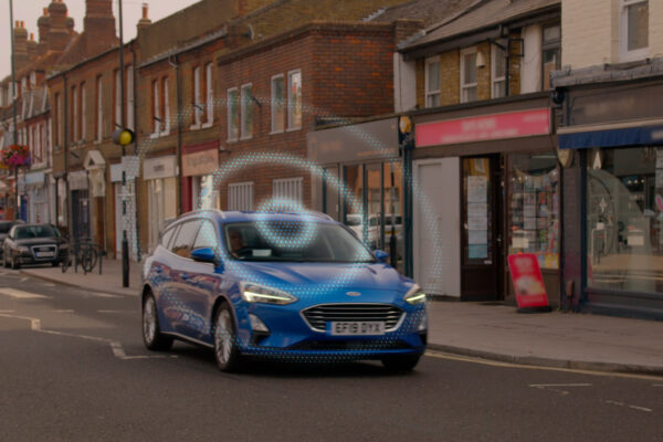
Technology from Ford identifies accident blackspots
Ford’s RoadSafe technology uses an machine learning algorithm that combines and analyses anonymised data from various sources. Data sources include connected vehicles, road sensors and traffic news. The aim is to identify where there may be an increased likelihood of traffic accidents. This information can then be displayed on a map that identifies risks and could also be used in the future to warn drivers of dangerous hotspots.
The digital tool is currently being tested in London and the UK county of Oxfordshire. More than 200 vehicles are taking part in the trials. “In every city, there are stretches of road with an increased likelihood of accidents, whether due to a badly placed road sign, an unrepaired pothole or outdated routing. Now we can pinpoint such problem areas so that motorists can be forewarned and authorities can take action,” explains Jon Scott, Project Lead, City Insights, Ford Mobility, Europe.
The data gathered enabled the development team to create a special map that identifies road sections of particular concern. This map is composed of different layers of data, including known past accidents and a risk prediction algorithm for each road segment. Colours are used to assess the likelihood of accidents, with red representing the highest risk and yellow the lowest.
To collect the data, the vehicles participating in the trials record relevant driving events such as braking, steering and accelerating. Roadside sensors, meanwhile, track the movements of various road users. The sensors use machine learning algorithms to detect near misses and analyse movement patterns of vulnerable road users such as cyclists and pedestrians.
The combination of vehicle and sensor data can help detect a variety of hazards. These include places where vehicles pass too close to cyclists or inconveniently located bus stops that cause congestion, as well as poorly designed roundabouts and intersections that cause confusion and near-misses.
In the future, such technology could also benefit passengers travelling in autonomous vehicles. Combining the vehicle’s on-board sensors with a digital hazard map could help them anticipate critical situations even earlier and adjust route management accordingly.
RoadSafe Video: https://youtu.be/OEn51lD8yxg
Related articles:
Mercedes adds pothole warning to Car2X functionality
Brainwave-based ADAS system promises safer driving
Bosch, Skoda bring wrong-way driver warning into real-time domain
Bosch develops automatic emergency call for motorcycles
Telefónica, Dekra open 5G connected driving test centre
Vodafone and Ford test digital parking guidance system
Smartphone magnet sensor protects pedestrians, cyclists
Technology aims at preventing “dooring” accidents
 If you enjoyed this article, you will like the following ones: don't miss them by subscribing to :