Google ‘Street View’ cars add sensors to map air quality
In the partnership, Google Earth Outreach will be installing Aclima sensors on its Street View cars, which are used to create the panoramic views and locations found on Google Maps. With the addition of the sensors, the vehicles – which are already equipped with cameras, lasers, and GPS – will now be able to track air pollution in real time.
The sensors will be able to measure nitrogen dioxide, nitric oxide, ozone, carbon monoxide, carbon dioxide, methane, black carbon, particulate matter, and volatile organic compounds (VOCs), as well as meteorology. The higher resolution picture of air quality at the street level will, the companies hope, enable more informed decision making by citizens, industry and policymakers.
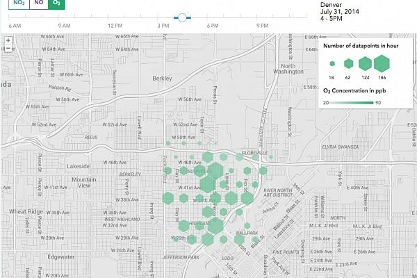
Initial testing of the project was performed in Denver, Colorado, where three Street View vehicles were outfitted with Aclima’s mobile sensing platform. Over the course of one month, the cars collected 150 million air quality data points with 750 hours of drive time, and confirmed that collecting street-by-street data was an improvement over existing stationary sensor networks operated by the Environmental Protection Agency.
"Many things affect air quality – everything from our transportation and energy choices, to green space and the weather," says Davida Herzl, co-founder and CEO of Aclima. "Understanding these complex relationships is critical to managing and improving air quality. The Denver test prepares us for scaling the system and introducing Aclima’s mobile sensing platform to communities anywhere Google Street View vehicles drive. There’s unlimited potential for our work to help improve the health and resilience of communities everywhere.”
The sensor platforms themselves were installed in the back of the Street View cars, with a hole in one of the car windows allowing for the capture of air samples through a series of tubes. Additional sensors – for measuring meteorological data like temperature and wind flow etc. – were mounted on the exterior of the cars. The companies plan to expand mapping efforts to the San Francisco area in the fall.
Aclima: Mapping How Our Cities Live and Breathe
 If you enjoyed this article, you will like the following ones: don't miss them by subscribing to :